
SITE INVESTIGATION, FACTUAL REPORTING & MAPPING
-
FACTUAL GROUND CONDITION REPORTS
-
"Good Ground" reports for house and shed foundations (up to IL2-TC2)
-
Pre-purchase and geo-hazard site assessments
-
Informative Geomorphology and Geological maps and plans
-
-
SITE INVESTIGATION
-
Hand Augers and Scalas
-
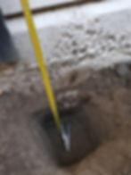
Hand Dug Test/Trial Pits for Foundation Checks
-
Borehole Logging
-
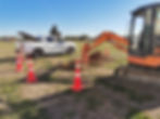
Machine Dug Test/Trial Pits
-
Construction Inspections
-
Factual Ground Condition Reporting
-
Deep Investigation Management & Supervision (Drilling & CPT's)
-
-
GROUNDWATER MONITORING
-
Electronic Transducer Monitoring
-
Piezometer Installs
-
Soakage & Permeability Testing
-
-
MAPPING & GEO-SURVEY
-
Geological & Geomorphological Mapping
-
Hazard Identification & Risk Mitigation Investigations
-
Precision GPS Survey
-
Cross Sections
-
-
SAMPLING
-
Specialist Sampling & Testing
-
Environmental Sampling
-
Sampling for Laboratory Testing
-
Undisturbed Sampling
-
With over 30 years experience in Site Investigation, mapping, drilling, project management, and construction, we have a deep understanding of all aspects of the Land that impact Design & Construction. We recognize the importance of acquiring accurate and reliable knowledge about the site throughout all project phases.
Different types of Site Investigations & Reports are necessary for Design & Consenting purposes and play a crucial role in Due Diligence and mitigating Construction Risks. The extent of investigation and reporting varies significantly based on the project type, scale and specific questions that need to be answered.
We provide comprehensive services, including site investigation, GIS mapping, and factual reporting for various clients, such as Purchasers, Land Agents, Developers, Consultants, Engineers, and Owners/Vendors. Our commitment is to deliver reliable and detailed information to support informed decision-making and successful project outcomes.


SOIL & GROUNDWATER INVESTIGATIONS
Knowledge of Soil Conditions underlying a site is crucial to manage costs and risk on any project.
We can help with Site Investigations for Ground Condition and Bearing Capacity, Soakage for Discharge to Ground, Groundwater and Monitoring, Soil Types, Geotechnical Hazards, Geology, Natural Resources, and more.
With over 30 years of Site Investigation and Drilling Management experience throughout Canterbury and New Zealand, we understand the ground and what is needed to investigate it. We have good relationships with Drilling and Excavation Subcontractors nationwide, and can therefore manage all scales of Site Investigation, including engaging subcontractors when required.
We are always happy to advise and help with bespoke and specialist sampling solutions, limited access sites and testing, and other challenging Site Investigation Projects.
FACTUAL ('Good Ground') REPORTING
For many domestic projects (including 'standard' houses and sheds) a basic shallow site investigation to identify "good ground" with an accompanying Factual Report prepared by us is typically sufficient for Building Consent.
If unfavorable ground conditions or issues are found during the initial site investigation then we can facilitate the engagement of a certified Geotechnical Engineer or other relevant consultants, only as and if required. These experts provide specialized design and certification where Council requires this level of input. As these Consultants trust our data they are happy to utilise the information gathered by our team up to that point - with no need for a factual reporting by us, just the field information. So there is no duplication of costs or delay.

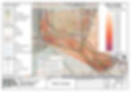
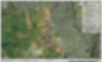
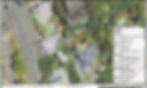
GEOLOGICAL MAPPING & SITE PLANS
High quality, accurate, informative, and professional maps, plans, sections, and other presentation graphics are critical to convey site information gathered in any investigation.
We have extensive experience in field mapping of geology, geomorphology, site features and geotechnical hazards for all scales of project; from domestic sites through to large scale infrastructure developments.
Accurate GPS field surveying combined with comprehensive GIS capabilities and our unique eye for detail and aesthetics means we consistently create high quality, accurate, informative and comprehensive maps, plans, and other report graphics for all scales of Land Development Project.